West of Thunder Bay

An Integrated Regional Resource Plan was released for the West of Thunder Bay sub-region in July 2016.

Community Engagement

The IESO engages with local and regional communities to seek input to help inform regional planning activities. An Integrated Regional Resource Plan (IRRP) from the latest West of Thunder Bay planning cycle was finalized in 2016. See engagement materials on the previous planning cycle.

Regional Planning Process Status

There is potential for renewed growth in demand associated with forecasted mining activities and resource development in various communities across the West of Thunder Bay sub-region. Due to its connection with the North of Dryden sub-region, this region's electricity supply can be affected by the potential for development in the area north of Dryden. Regional planning will provide options to address the potential for demand growth, considering both the limits on the existing supply to the area, and opportunities for coordinating demand and supply options.


Documents referenced on this page, but not posted, can be obtained by contacting customer.relations@ieso.ca with a link to the web page that lists the document and advise whether it needs to be provided in an accessible format. Please allow a minimum of one business day for a response.


2016 West of Thunder Bay IRRP - Appendices

 
IRRP Working Group - Next Steps

A Working Group consisting of the local distribution companies in the region, the local transmitter and the IESO will make recommendations to address the longer-term needs in the region based on planning criteria and consideration of community input.

The Working Group currently consists of representatives from Atikokan Hydro, Kenora Hydro, Fort Frances Power Corporation, Sioux Lookout Hydro Inc.,  Hydro One Distribution, Hydro One Transmission and the IESO. 

Area Overview

West of Thunder Bay - Map
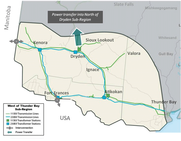
For regional planning purposes, the West of Thunder Bay sub-region is defined as the area bordered to the south and west by the United States and Manitoba borders, and extending north to include Kenora, Dryden and Sioux Lookout, and east as far as (but not including) the City of Thunder Bay.

The sub-region includes the City of Kenora, the City of Dryden, the Town of Fort Frances, the Town of Sioux Lookout, the Town of Atikokan and surrounding towns, townships and communities in unorganized districts. A full listing of the municipalities in the regional planning area can be found in the draft terms of reference document.

The West of Thunder Bay sub-region also includes the following First Nations:

Anishinabe of Wauzhushk Onigum
Anishinaabeg of Naongashiing
Big Grassy, Couchiching
Eagle Lake
Grassy Narrows
Iskatewizaagegan #39
Lac Des Mille Lacs
Lac La Croix
Lac Seul
Mitaanjigamiing
Naicatchewenin
Naotkamegwanning
Nigigoonsiminikaaning
Northwest Angle #33
Northwest Angle #37
Obashkaandagaang
Ochiichagwe'Babigo'iIning
Ojibway Nation of Saugeen
Ojibways of Onigaming
Rainy River
Seine River
Shoal Lake #40
Wabaseemoong
Wabauskang
Wabigoon Lake Ojibway


In planning for this sub-region, it is necessary to consider the power transfer requirements into the North of Dryden sub-region primarily from the Dryden station. See more information on the North of Dryden sub-region. The West of Thunder Bay sub-region is also interconnected with Manitoba at Kenora and Minnesota at Fort Frances.